Date: Saturday, June 6, 2015
Time: 8:00a start
Start Location: Upper Siouxon Trailhead
Distance: 22 miles
Starting/Min/Max Elevation: 1830’/4100′
Elevation gain/loss: 5,000′
Max Riders: 75
Cost: FREE
Registration: CLOSED
WARNING: The course is not marked. You are on your own to find your way. Make sure you are prepared for a backcountry experience. Make sure somebody knows where you’re going and when you will be back. We will not come looking for you. Make sure you know our rules.
Overview: Only 22 miles, but has 5,000′ of climbing and should take between 3-6 hours to complete. Siouxon Creek Trail is one of the best trails for mountain biking in the northwest. It has incredible flowy singletrack, ripping descents, challenging rocky areas, creek crossings, and some of the most beautiful waterfalls and clear pools around – period. Adding in the climb to Siouxon and Huffman Peaks makes this brutally hard, adds incredible views of Mt St Helens, Mt Rainier, Mt Adams, and Mt Hood and gives you a killer 7 mile descent. Read more about this ride here
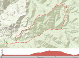
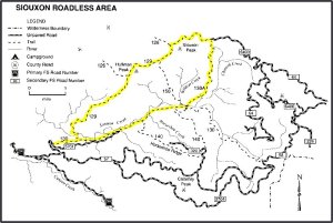
Route: The ride starts the upper Siouxon Trailhead just past the hairpin off road 5701. At 1.2 miles you’ll see the Huffman Peak trail come in from the left that you will return on, but continue straight on Siouxon Trail. At 3.2 miles you will come to the official Siouxon Trailhead where all the hikers start from. If you’re going to see any hikers it’s going to be in the next 4.2 miles so use caution and be very courteous.
At 7.4 miles there is a bridge to the left that crosses Siouxon Creek. Take the bridge/trail (Trail 130A) to the left. After a quarter mile, the trail drops down to the creek at Chinook Falls. There is a log you can cross on that takes you directly to the trail on the other side.
Continue past the creek a quarter mile to a trail intersection at mile 7.9. Make a sharp right at the trail intersection to stay on Trail 130A. This is where the climbing begins. At mile 11 you intersect with road 6403. Take a left on the road and it almost immediately turns back into trail and begins climbing towards Siouxon Peak.
Once you’ve reached Siouxon Peak at mile 13.3, the trail is mostly downhill until you get to Siouxon Creek. It drops 3,000′ over the next 7 miles. The first trail you get to is Wildcat Trail that goes to the left at around mile 14.5. Do not take this as it will take you back down close to Chinook falls. The next trail intersection you get to is at mile 16.1 and you want to go left to stay on the Huffman Peak Trail. Take that about 4 miles downhill until you get to Siouxon Creek. Cross the creek to the trail on the other side. Take the trail about up 0.3 mile to Siouxon Creek trail. Take a right and it’s just a hard 1.2 miles back to the finish.
Here are a couple of maps of the route and a click-able Ride With GPS link.
 |
 |
Cue Sheet: 2015 Siouxon with a View Cue Sheet
Water on the Course: The 2 stream crossings are the best places to get water. These are at mile 7.7 and mile 20.1. There is very limited water available between these.
Directions to the Start: Google Map to the start of Siouxon:
Travel-time to the start is 75 minutes from downtown Portland. You won’t have cell coverage at the end so it’s probably best to make sure you have these with you.
- Take I-5 North from Portland into Washington to the Battleground Exit (exit 11).
- Take a RIGHT at the exit and go East on 502 (also called 219th Street and turns into Main Street).
- Go East for 5.5 miles and take a LEFT on 503 (also SW 10th Ave). Note that this is the first “big” intersection/light you come to with 2 turn lanes to the left.
- Follow signs to Amboy and stay on this road for about 13 miles until after you pass through Amboy.
- When you come to a stop sign at a T intersection, take a RIGHT on Cedar Creek Lane.
- Follow this a few miles until you go past a Mt. St Helens visitor center on your left and see a store/gas station on your right.
- This is the town/area of Chelatchie. Take a RIGHT on NE Healy Rd – which is the street immediately before the store/gas station.
- You’ll stay on this road until you get to the FIRST paved road that splits off to the left – which is about 10 miles after you turned onto Healy Rd.
- Take this LEFT on NF road 57 (also called Calamity Peak Rd on the map, but there is no sign for it. I think there is a “57” sign)
- Go about 1 mile up this road to the first paved road on your left.
- Take a LEFT on this road (5701 on the map, don’t remember there being a sign)
- Go about a half mile down this road until you get to a hairpin turn to the right. Park in the gravel area at the outside of the hairpin and get ready here. This is the destination point on the Google Map link above.
Camping: There are some primitive sites right after you turn on to road 5701. If you don’t mind ride/hike in camping, there are a lot of fantastic primitive campsites along Siouxon Creek trail.

Any plans for a 2016 Siouxon ride?
Hey Jeff, Last year this ride only had 1 rider other than myself and my 2 training buddies. I was a bit surprised because this is an awesome route. But I decided to put on fewer rides this year and focus on them a little more. I am however planning on doing this ride on June 4 with 5 other riders. If you’re looking for having some other people around, I can let you know the details. Cheers – Mike